Introduction
Understanding the calculation of lots and blocks is crucial for professionals in real estate, urban planning, and construction. Lots and blocks refer to the method used to divide land into manageable pieces, a fundamental concept in creating subdivisions or plotting cities. Calculating these can be complex, involving considerations of area size, zoning laws, and geographical constraints.
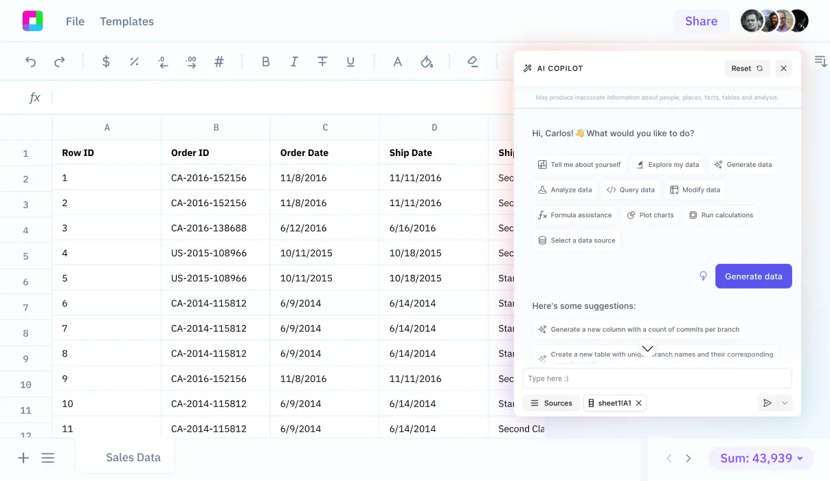
To streamline and simplify these calculations, modern tools like Sourcetable are essential. Sourcetable’s AI-powered spreadsheet assistant optimizes the process by minimizing errors and maximizing efficiency. We'll explore how Sourcetable lets you calculate this and more using its AI powered spreadsheet assistant, which you can try at app.sourcetable.com/signup.
See how easy it is to how lots and blocks are calculated with Sourcetable
How Are Lots and Blocks Calculated?
The calculation of lots and blocks in land development is a systematic and precise process. It begins with a subdivision survey, delineating a large tract of land using either the metes and bounds system or the Public Land Survey System. The subdivision survey divides this large tract into smaller, manageable lots, essential for development in metropolitan, suburban, and exurban areas.
Creating the Plat Map
A crucial step in calculating lots and blocks is the creation of a plat map. This map is generated during the subdivision survey and displays individual lots within the larger tract. Each lot is assigned a unique identifier, typically a number or letter. The plat map's accuracy is vital as it forms the basis for all future legal descriptions of the lots and their respective dimensions.
Recording and Legal Documentation
After the plat map is created, it must be recorded with a relevant government entity. This recorded plat map becomes the official and legal description of all the subdivided lots, ensuring clear and undisputed ownership boundaries. It also facilitates the accurate calculation of property taxes and aids in risk management for potential owners.
Overall, understanding and implementing the lot and block calculation process is crucial for accurate land identification and utilization, helping to streamline property development and legal documentation.
How Are Lots and Blocks Calculated?
The Lot and Block Survey System is a prevalent method for calculating and subdividing land particularly in urban and suburban areas of the United States. This method is integral for defining real estate boundaries in densely populated regions.
Understanding the Plat Map
A plat map serves as the foundational tool in the Lot and Block system. It illustrates the division of land into blocks and lots, which are based on the layout of roads within a subdivision. This map is essential for accurately identifying and recording property boundaries.
Steps in the Lot and Block Calculation
To initiate the calculation, land is first measured using the metes and bounds system, which relies on natural landmarks and cardinal directions to describe boundaries. Post-measurement, the land is subdivided into blocks following the existing or planned road infrastructure.
Each block is then divided into smaller parcels known as lots. These lots are the smallest parcels in the system and are sold individually. The entire subdivision plan, including lots and blocks, is recorded on a plat map, which is then filed with local government authorities. This recorded plat map establishes the legal description of each property, crucial for tax assessments, legal claims, and property identification.
Legal and Practical Relevance
The legal descriptions derived from plat maps, such as "Lot 12, Block 28, SUNRISE ON THE WATER subdivision..." become essential for a multitude of administrative and legal processes. They allow property to be clearly identified in terms of ownership, and are helpful in resolving disputes about property boundaries.
This system not only simplifies the process of land development but also ensures a standardized method to manage and reference property legally and efficiently in densely populated environments.
Try Sourcetable For Free
Calculate anything with Sourcetable AI. Tell Sourcetable what you want to calculate. Sourcetable does the rest.
Sign Up
Calculating Lots and Blocks: Practical Examples
Example 1: Rectangular Subdivision
Consider a rectangular plot intended for subdivision into equal lots. If the total area of the plot is 12,000 m^2, with individual lot sizes planned at 600 m^2, divide the total area by the individual lot size to determine the number of lots. Using this method, the subdivision yields 20 lots.
Example 2: Block Division in Urban Planning
In urban planning, a block is split according to street access and zoning requirements. For a block with an area of 15,000 m^2 surrounded by four streets, a common approach is to divide it into smaller blocks of 2,500 m^2 each. This consideration results in 6 blocks, assuming efficient use of space and adherence to city planning regulations.
Example 3: Irregularly Shaped Parcel
Dividing an irregularly shaped parcel requires calculating the area via geometric methods or GPS measurements. If an irregular parcel covers 10,000 m^2 and the desired lot size is roughly 500 m^2, distribute the area by dividing the total area by the lot size. This configuration results in approximately 20 lots, taking into consideration any unusable space due to the irregular shape.
Example 4: Mixed-Use Development
For mixed-use developments that integrate residential, commercial, and recreational areas, calculation varies by intended land use. Assuming a total development area of 30,000 m^2, with planned allocations of 40% residential, 30% commercial, and 30% recreational, calculate each section separately and then design the layout. This involves detailed planning to optimize space and functionality, potentially resulting in diverse lot and block configurations.
Discover the Power of Sourcetable for Accurate Calculations
Sourcetable transforms the way you calculate, making complex computations as simple as typing a question. This AI-powered spreadsheet is not only intuitive but also highly efficient, ideal for an array of academic and professional applications.
How Sourcetable Simplifies Calculations of Lots and Blocks
Understanding how to calculate lots and blocks is crucial in fields like real estate and urban planning. Sourcetable’s AI assistant excels in these calculations. Just enter your data, ask your question, and watch as Sourcetable does the heavy lifting. It displays results directly in the spreadsheet and details the methodology in a clear, chat-based interface.
Whether you are studying for school, analyzing data for work, or just curious about spatial data calculations, Sourcetable offers a reliable and straightforward solution. Its ability to break down complex calculations into understandable steps ensures accuracy and enhances learning.
Try Sourcetable today and experience the future of calculations. Its powerful AI makes it a superior tool for anyone needing precise, quick, and clear calculations.
Use Cases for Calculating Lots and Blocks
Real Estate Transactions |
Accurate calculations of lots and blocks enable clear legal descriptions necessary for the buying and selling of properties. This prevents boundary disputes and ensures smooth property transfers. |
Property Development Planning |
Developers utilize lot and block calculations to design subdivisions. This involves planning the layout of roads and utility placements effectively based on the subdivided lots and blocks. |
Property Tax Assessment |
Knowing how to calculate lots and blocks facilitates precise property valuations for taxation purposes. It ensures fair and equitable tax assessments by accurately defining property boundaries. |
Legal Documentation |
Lot and block calculations provide the necessary details for legal documentation such as deeds and titles. This reduces ambiguity in property ownership and aids in legal disputes concerning property boundaries. |
Frequently Asked Questions
What is the initial step in calculating lots and blocks in real estate?
The initial step in calculating lots and blocks is conducting a subdivision survey, which divides a large tract of land into smaller lots and is documented on a plat map.
How is the plat map used in the lot and block survey system?
The plat map created from the subdivision survey is recorded with a government entity and becomes the legal description of the lots in the subdivision, detailing the block and lot divisions.
What factors should be considered when calculating lot sizes?
When calculating lot sizes, factors such as land use regulations, building codes, utility access, setbacks, easements, soil conditions, topography, and environmental regulations must be considered.
Why is the Lot and Block Survey System particularly used in urban and suburban areas?
The Lot and Block Survey System is used in urban and suburban areas because it efficiently manages and identifies land parcels in densely populated regions, facilitating residential and commercial property development.
How does the Lot and Block Survey System differ from other land survey systems?
The Lot and Block Survey System, also known as the recorded plat survey system, is simpler and primarily used to identify land parcels in metropolitan, suburban, and exurban areas, unlike other systems which might use natural landmarks or cover large tracts of land.
Conclusion
Understanding how lots and blocks are calculated is crucial in fields like real estate and urban planning. These calculations often involve determining area measurements and understanding property boundaries, typically requiring complex mathematical operations. Sourcetable can greatly facilitate these calculations by offering an AI-powered spreadsheet designed for ease and efficiency.
Sourcetable for Easy Calculations
With Sourcetable, performing calculations on lots and blocks becomes straightforward. This powerful tool simplifies tasks that traditionally would take considerable time and effort. Sourcetable also enables users to experiment with AI-generated data, providing a unique opportunity to test calculations in varied scenarios.
For anyone looking to streamline their calculation processes, Sourcetable offers a compelling solution. Experience the benefits of AI-driven calculation tools without any cost. Start by visiting app.sourcetable.com/signup to try Sourcetable for free.
Try Sourcetable For Free
Calculate anything with Sourcetable AI. Tell Sourcetable what you want to calculate. Sourcetable does the rest.
Sign Up
Recommended Guides
Connect your most-used data sources and tools to Sourcetable for seamless analysis.
Calculate anything you want with AI
Sourcetable takes the math out of any complex calculation. Tell Sourcetable what you want to calculate. Sourcetable AI does the rest. See the step-by-step result in a spreadsheet and visualize your work. No Excel skills required.